Valencia, a City Told Through Its Buildings
Valencia, a City Told Through Its Buildings
Valencia is not only Spain’s third most populated city: it is also a mosaic of eras that can be read in the age of its housing stock. From the modernist movement of the early 20th century to the residential blocks of the 1970s, and more recently the revitalization of its historic center and maritime façade, the city tells its own story through architecture.
The Weight of the 20th Century in Valencia’s Housing Stock
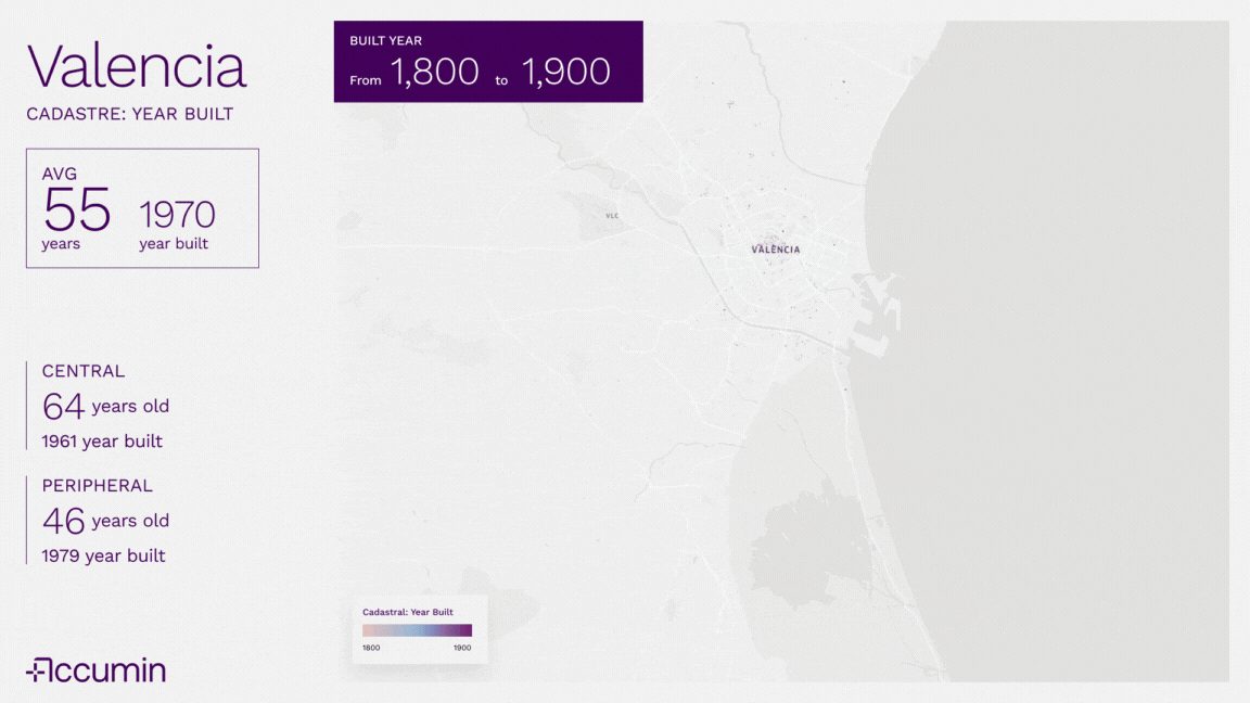
The average age of Valencia’s housing is 55 years, with an average construction year of 1970. This figure reflects the major urban push of the second half of the 20th century, when tourism and demographic growth fueled rapid construction.
- Historic center: average building age of 64 years, dating back to around 1961. Here, modernism, rationalism, and art déco dominate, symbols of a city eager to project modernity.
- Periphery: much younger, with an average age of 46 years. Neighborhoods such as Benicalap, Torrefiel, and Nou Moles expanded during the 1970s and 80s with functional housing estates and collective residential blocks adapted to a growing population.
Urban Trends: From the Periphery to the Sea
Until the late 1990s, the periphery absorbed most of the construction boom. Cheaper land and demographic pressure pushed growth towards the outskirts and areas near the port.
But from the 2000s onwards, urban trends shifted:
- Historic center: neighborhoods like Ruzafa or El Carmen moved from decline to becoming cultural, gastronomic, and residential hubs thanks to rehabilitation and gentrification.
- Coastal areas: from El Cabanyal to La Malvarrosa, Valencia’s maritime façade gained prominence through urban projects tied to major events (America’s Cup, Formula 1) and a renewed tourism push.

The Impact of Climate Risks on Urban Planning
The urban evolution of Valencia cannot be understood without the extreme climatic events that shaped its recent history.
- In 1957, the catastrophic Turia flood caused the river to overflow after torrential rains, killing 81 people and destroying entire neighborhoods. This disaster forced the city to rethink itself: the Turia riverbed was diverted out of the urban core, creating today’s Jardín del Turia.
- In 1982, the Tous dam collapse again revealed the vulnerability of the region: more than 30 people died and material losses were severe.
- More recently, episodes like the 2024 DANA storm have highlighted that flooding risk remains one of the city’s greatest planning challenges. Climate change will likely increase the frequency of such events.
Today, the integration of climatic, historical, and urban data is essential to design more resilient cities. Platforms like Accumin Intelligence make it possible to anticipate scenarios, cross-check territorial data, and plan safer, more sustainable urban developments.
A City Reinvented in Cycles
The evolutionary map of Valencia (1800–2025) reveals three key phases:
- A compact historic core, preserving the city’s heritage.
- An expansive periphery during the 1960s–80s, when Valencia grew at an unprecedented pace.
- The return to the center and the coast in the 21st century, where tradition and modernity now converge.
Architecture and Resilience as Urban Identity
Valencia’s building history is also the story of its identity:
- from a traditional Mediterranean city,
- to a modern metropolis with expanding neighborhoods,
- to a place that revalues its heritage while facing the challenges of climate resilience.
Walking through Valencia today means exploring an urban narrative where each façade, each neighborhood, and each decade leaves its mark—while the memory of past floods reminds us that architecture not only beautifies, but also protects.

Gerardo Raído